For a major hydropower project in Nepal, we assessed how climate change could affect rare floods and compound hazards, providing evidence for infrastructure design review and future flood-hazard mapping in vulnerable mountain communities.
Synthetic flood years
Future Q100 increase
Compound stress-test peak
Stress-test vs. annual peak
Flood risk under a changing climate
Flood protection and infrastructure design are increasingly being asked to look beyond the climate of the past. Through the Swiss Agency for Development and Cooperation's (SDC) Regional Climate Action Partnership in the Hindu Kush Himalayas (ReCAP), hydrosolutions is contributing to climate-resilient flood-risk assessment in Nepal, where high-mountain hazards affect communities, infrastructure, and hydropower development. These questions are especially sharp where rainfall, snow, glaciers, steep terrain, and short response times interact in ways that are difficult to capture with conventional flood-frequency methods.
For the Dudhkoshi Storage Hydroelectric Project (DKSHEP), we assessed monsoon flood hazard under climate change as part of the ADB-led BARHKH project and its risk-review process. The case study shows how climate information, physically based hydrology, stochastic simulation, and compound-hazard stress testing can be combined for critical infrastructure in data-scarce mountain regions.
A process-based model for data-scarce mountain basins
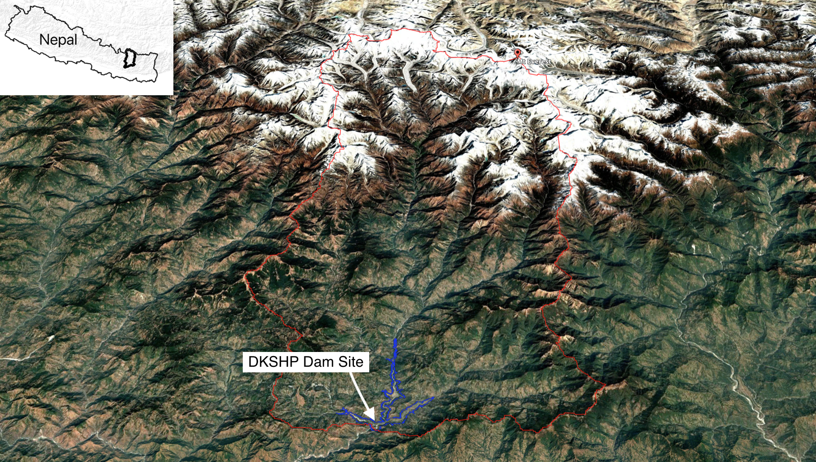
The Dudh Koshi basin drains the Mount Everest region, from glacierized terrain close to the world's highest peak at 8,849 m a.s.l. down to the planned DKSHEP dam site at about 460 m a.s.l. (Figure 1). Flood response in this high-mountain catchment depends on the timing and intensity of monsoon rainfall, the elevation of the snowline, glacier and snow storage, soil-water conditions, and routing through a steep river network. Observations are limited: little more than seven years of hourly streamflow data were available, supported by meteorological datasets and satellite observations used to check whether the model represents snow dynamics realistically.
To make the best use of this evidence, the analysis used TOPKAPI-ETH, a physically based glacio-hydrological model developed at ETH Zurich. The model simulates the catchment hour by hour, including snow and glacier processes, soil-water storage, runoff generation, and river routing. This matters because rare floods in mountain basins are not controlled by rainfall alone. They also depend on the state of the catchment before and during the event.
The work also connects directly to our recent collaboration agreement with ETH Zurich on TOPWATCH, the modernised successor of TOPKAPI-ETH in the same modelling lineage. TOPWATCH is being developed for workflows where computational efficiency is essential, including stochastic risk analysis and climate stress testing with large model ensembles.
From hourly simulations to rare flood events
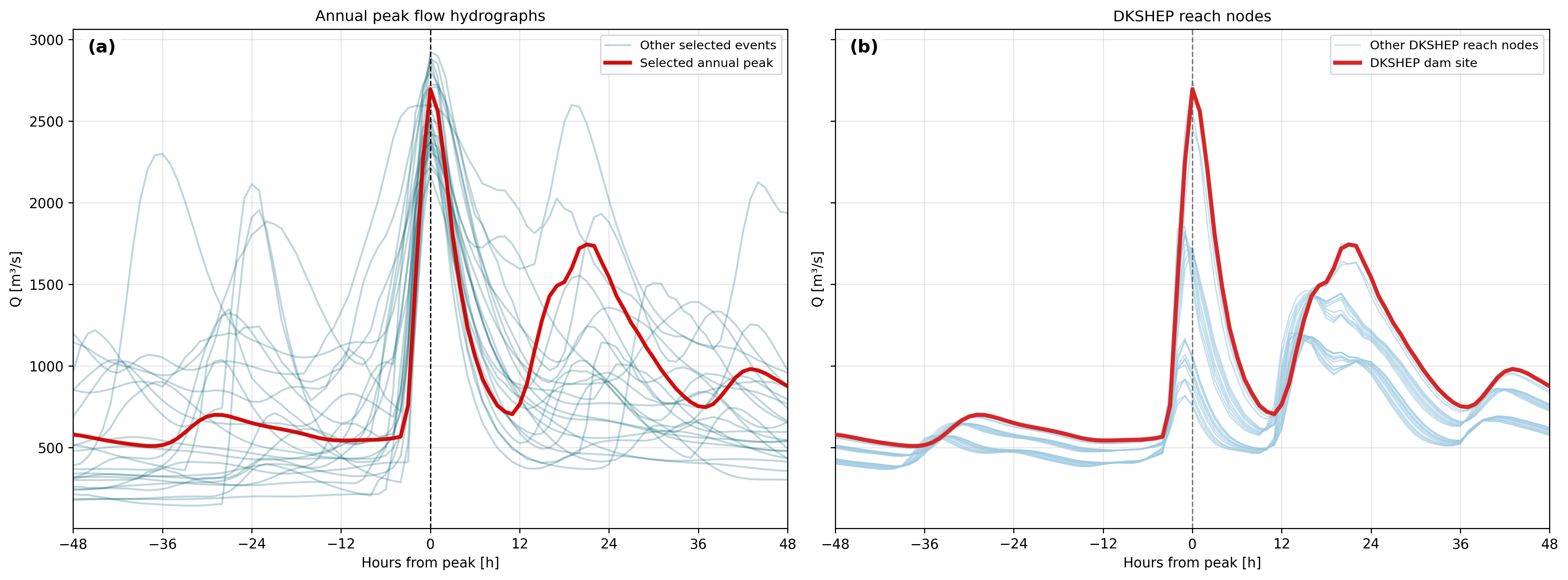
Available observed records are rarely long enough to estimate rare floods with confidence. This is especially true for Q100, the 100-year flood estimate, and for even rarer events used in infrastructure design reviews. The Dudh Koshi assessment therefore generated stochastic flood ensembles, meaning many plausible synthetic flood years derived from the TOPKAPI-ETH based model output (Figure 2). In total, the workflow used 100,000 synthetic flood years to support flood-frequency analysis.
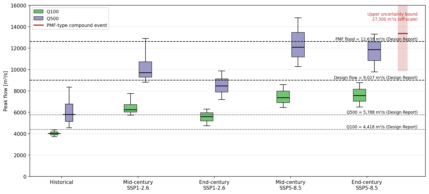
The results indicate a substantial climate signal. Across the assessed future scenarios, the Q100 monsoon flood peak increased by about +39% to +87% relative to the historical estimate. The dominant diagnosed driver was stronger short-duration rainfall before flood peaks; warmer conditions and higher snowlines also matter, but rainfall intensity explained most of the increase in this case.
This represents a step beyond earlier hydrosolutions work on climate impacts on flood frequencies. That earlier case study used stochastic rainfall generation and rainfall-runoff modelling to extend limited observations. The Dudh Koshi assessment goes further by using continuous physically based glacio-hydrological modelling in a high-mountain setting where process interactions are central to flood response.
Stress-testing compound hazards
For high-mountain infrastructure, monsoon floods are only part of the story. The DKSHEP design report provides the project design hydrology benchmarks, but it did not explicitly assess climate-change impacts using the process-based and stochastic workflow applied here. ADB therefore requested additional evidence from the Swiss Consortium under BARHKH, so that future flood loading could be reviewed before the expected loan-approval decision for the hydropower project.
The Dudh Koshi assessment therefore considered not only climate-adjusted monsoon flood peaks, but also a Probable-Maximum-Flood (PMF)-type compound stress test, a deliberately conservative scenario in which high monsoon flow is combined with glacial-lake outburst and cascading flood processes. This compound-event assessment was developed in collaboration with experts from the University of Geneva and the University of Zurich, linking hydrosolutions' monsoon flood analysis with glacial-lake and cascading-hazard expertise.
The comparison with design values is central. Historical Q100 and Q500 estimates from the updated analysis agree well with the design-report benchmarks (Q100 about 9% lower; Q500 about 0.2% higher; see Figure 3). However, the projected future intensification of monsoon floods suggests that the adequacy of the current extreme-flood design assumptions should be re-examined under future climate conditions. Projected future Q100 and Q500 peak flows increase by +39% to +87% and +47% to +109%, respectively, which means that rare flood events could approach or exceed current extreme-flood design benchmarks under future climate conditions. The compound-event stress test provides additional evidence for reviewing whether existing design flood assumptions remain conservative under future monsoon and compound-hazard conditions. The largest future flood stress tests considered here exceed the historical mean annual peak flow by about 6.3x to 17.5x. Such conditions and hazard combinations in the Himalayas require conservative safety margins.
From Nepal to climate-resilient planning
The Dudh Koshi case demonstrates a transferable approach for mountain flood-risk assessment. It enables climate-adjusted flood-frequency estimates, better use of short observational records, stress tests for critical infrastructure, assessment of compound monsoon and glacial-lake hazards, and workflows that can support both Swiss and international planning contexts.
The next step is to translate the flood-frequency results into spatial hazard information. We will use the updated peak-flow and hydrograph estimates as inputs to a hydrodynamic model and generate revised flood-hazard maps for vulnerable communities in the Dudh Koshi basin. This link from climate-informed hydrology to local hazard mapping is also highly relevant in Switzerland. For example, the Canton of Zurich's recent work on natural-hazard risks in 2050 and 2100 asks how protection measures can remain effective as heavy rainfall intensifies and peak flows increase.
The approach does not remove uncertainty in future monsoon rainfall or rare-event extrapolation, but it makes these uncertainties visible in a physically consistent modelling framework. That is the core value for decision-makers: not a single deterministic answer, but a transparent basis for asking whether flood-protection measures and infrastructure designs remain robust as climate conditions change.
Disclaimer
The findings, analyses, and interpretations presented here are those of hydrosolutions GmbH and do not necessarily reflect the views of SDC/FDFA.
Downloads
More Projects